A foolproof way to guarantee the yolk comes out the way you want it – soft, medium or hard boiled – every time. Carrying a special label, the egg goes into your pan as normal and when it is perfectly cooked the Lion logo appears as if by magic confirming your chosen preference.
Month: July 2006
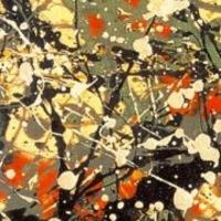
Jacson Pollock
There is something about an artist that is undeniably intriguing. The public expects their daily lives to be somehow different, filled with the dreamy eccentricities of Dali or the tormented thoughts of Munch. We want their life stories to play out in dramatic form so we see the bridge between the creator and the creation. Because this summer’s Guggenheim exhibit focuses on one of the Greatest American Painters of the 20th Century, The New Yorker has taken a look into the life of Jacson Pollock. He is the lead of his own bildungsroman.
Don’t Drink and Walk
Public Service Announcement: Drinking to excess and walking don’t mix.
Additional Tip: If there’s a high probability of falling flat on your face, keep your hands out of your pockes.
Alaska is Big
Q1. What’s the farthest state north?
Q2. What’s the farthest state west?
Q3. What’s the farthest state east?
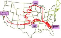
If Alaska were superimposed over a map of the lower 48 (as you can see in the image [above]), its western tip would sit in Sacramento, CA, its northern tip in Duluth, MN, and its eastern tip in Savannah, GA.
A1. Alaska
A2. Alaska
A3. Alaska – It goes past 180 degrees west.
Concept Cars
Concept Cars from 1936 to 1969.
Chrysler’s above-the-fender taillights from 1951 1952 and 1953 made it to prodution in 1962.
Much more information at Concept Carz.
Parking Spots
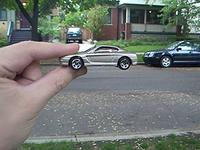
Want to have fun today? Right now? Submit a photo to Dubi Kaufmann’s Parking Spots. Make sure you follow the rules:
1. Shoot a toy car next to a real one.
2. Make the toy car look like a real car by having it seem to be the same size.
3. look at the pictures in the gallery to get the idea.
4. Take the picture.
5. Have your method of holdnig the small car in place be visible. In other words let the people see your hand,tripod or a rail.
6. Make your image a 300 by 225 JPG.
Making your digital picture the correct size is easy.
Now, if I ever have to choose between a Bugatti EB110, a Mercedes SLK 230, and a BMW Z3, I’ll know which one looks best in my driveway.
Naval Safety Center
Microwave Radiometer
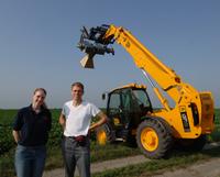
For decades, Iowa State University researchers have studied the cycling of water among soil, vegetation and the atmosphere that is vital to production agriculture. Now a team of Iowa State and University of Iowa researchers is beginning a new project to perfect the use of remote sensing technology to monitor the water cycle.
~
Eventually microwave remote sensing instruments on satellites will take pictures of the earth’s surface and produce maps of soil moisture.
~
The ultimate goal would be to someday use this type of information in conjunction with models to forecast soil moisture conditions, the weather and to detect climate change.
Keyring Kite
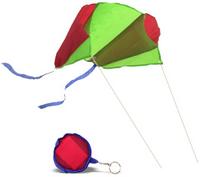
Designed to fold down into a tiny keyring pouch, when unfurled, our strutless parafoil kite presents a magnificent wing span of 45cm and 30m of bridle string for easy flying in almost any conditions.
Middle East Buddy List

Slate’s Middle East Buddy List breaks down the relationships between the countries, terrorist organizations, and political factions who are fighting it out in the current conflict.


