Living History Farms

Living History Farms

Living History Farms in Urbandale, Iowa, tells the amazing story of how Iowans transformed the fertile prairies of the Midwest into the most productive farmland in the world. While at the 550-acre open-air museum, visitors travel at their own pace through five historical time periods spanning 300 years. On-site interpreters provide a unique learning environment of seasonal activities and demonstrations. A complete visit lasts three to four hours.

Every day at Living History Farms presents new activities to help you Get Your Grip on history.

The farming techniques practiced by the Ioway Indians in 1700 pre-dated history and varied somewhat from European methods. Ioway farmers raised corn, beans and squash.

Activities included Tanning a Deer Hide.

Until pioneer families earned enough money to purchase modern 1850 technology, they relied on older farming methods. For example, women prepared food over an open fire even though wood-burning cookstoves were available. The majority of people who settled in Iowa in the 1840s and 1850s came from the Eastern United States ~.

Activities included Making Soap.

In the 1875 town, you can see early evidence of the Industrial Revolution in the mass-produced furniture of the upper-class home, the factory goods in the general store, and the labor-saving machinery in the carpenter’s shop. When railroads arrived at towns like this, the craftsmen gradually disappeared, being undersold by eastern factories, and the towns shifted even more heavily to service and retail functions.

Activities included Binding Brooms

Technology had reached Iowa farms in 1900, by way of the hand-crank telephone, Acorn cook stove, and updated farm equipment, such the horse-drawn plow, planter, hay press and more.

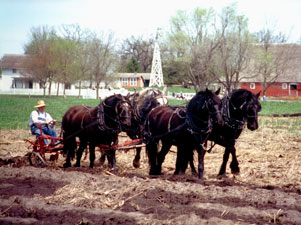
Activities included hauling manure.

TravelAmerica Magazine’s top 20 tours in the United States includes Living History Farms as a highlighted stop.

I live near Living History Farms, and I think it’s a very high quality operation. I recommended it to anyone traveling through Iowa.

Chesapeake and Ohio Canal

C&O Canal

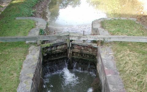
One of the best preserved and least altered of old American canals, the Chesapeake and Ohio grew from Washington’s vision of linking the valleys of the early west with the east by “ties of communication.” The Potomac Company fostered by Washington to improve navigation of the Potomac transferred its rights in 1828 to the Chesapeake and Ohio Company organized to connect the Ohio at Pittsburg with Georgetown by a continuous canal. In October 1850 after 185 miles were built the construction ceased at Cumberland. Until 1924 trade continued on the old canal. Today, it is a memorial to national progress and the canal era.

The history of the canal runs parallel with the history of the B&O Railroad. You can check Steve Okonski’s B&O RR Photo Tours site for a mile-by-mile guided tour of the B&O routes heading out from Baltimore.

The Dammed Mississippi

Dam 13

Among those involved in remaking the Mississippi was a Germanborn mapmaker, Henry Peter Bosse. Coming to America in 1870, the twenty-six-years-old immigrant joined the Corps four years later and was sent to draw the river from St. Paul, Minnesota to St. Louis, Missouri. But the draftsman did more; he took at least 350 large format photographs between 1883-93, as he worked his way 729 miles downstream from the upper limit of navigation.

“U.S. Agriculture depends utterly on a viable transportation network to enable farmers to access the world markets. We produce far more commodities such as corn than we could ever hope to consume domestically, and the competition from the export market forces domestic users to bid competitively for those commodities, keeping prices above the cost of production.

Water transportation moves 16% of our nation’s freight for 2% of the freight cost. Compared to alternative modes, barges save shippers and consumers more than $7 billion annually.

One gallon of fuel can move one ton of cargo 522 miles by barge, 386 miles by rail and 59 miles by truck.

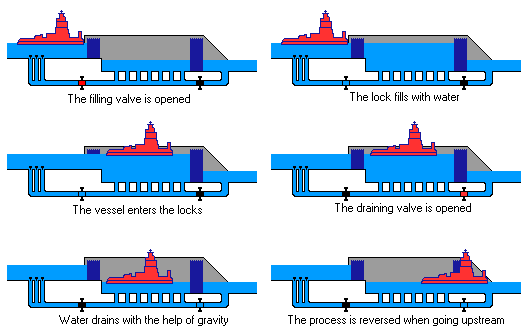
Locks Working

Take a dam tour.

Watch the dam cam.

The Mississippi River Basin is made up of several Subbasins.

Map of Iowa’s locks and dams along the Upper Mississippi.

This photo was taken moderately high.

This photo was taken dam high.

More dam photos.

The dams do not control floods; during high water, the dam gates are raised out of the water. Below St. Louis, the river is deep enough so that locks and dams are not needed for commercial navigation.

In general, dams transform rivers into lakes and impoundments. The resulting changes in water depth, water currents, temperature, and restructured fish and algal communities can negatively affect freshwater mussels.